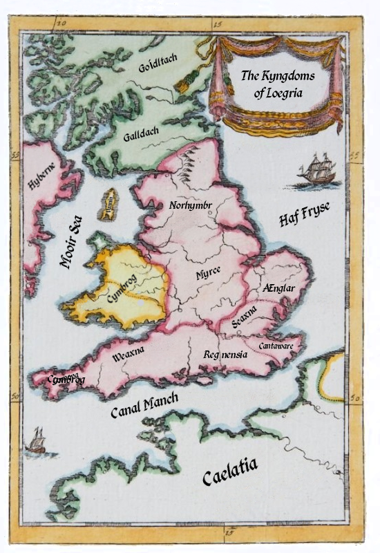
Loegria
Loegria (low-EGG-ree-uh) is the largest contree in Albyrne.
Geography
The region includes seven kingdoms.
Norhymbr, to the north, contains six shires: Bryneich, Carliol, Deifr, Durese, Jórvík, and Lonassre.
Myrce, the largest of the kingdoms, occupies the central area of both Loegria and Albyrne known as the Middelonde, and is divided into twenty-two shires.
The Tennemann occupied area in the east, known as the Denalagh, covers the former kingdoms of Seaxna and Ænglar.
In the south are the kingdoms are Weaxna, Regnensia, and Cantaware.
Population
The native people of the region are the Meadhón, or Middle Elves.
Roadways
The main roadways of the contree are know collectively as the Feower Heahweg Loegrian (Four Highways of Loegria).
- Fossa Weg, another Imperial road, runs north from Escanceaster, Weaxna into Myrce, crossing Wæclina Stræte south of Ledestre in Laegress and joining with Iccenhyld Weg in Lincylene.
- Iccenhyld Weg, one of the oldest roads in Albyrne, connects Norulca in Ænglar to Widtun in Weaxna.
- Wæclina Stræte is an ancient trackway first paved by the Empire. It begins in Rutæpi, Cantaware and runs west into Myrce where it crosses the Temesis river in Lundenwic then turns northwest through Verlumion on to Wrocænse.
The Viae Imperiālis (Imperial Roads) were all built or improved by the Human Empire
- Acemanne Rode connects Cyrneceast in Weaxna to Verlumion in Myrce
- Chamelet Weg runs roughly east–west from Colnceastre in Seaxna to Selcoill via Verlumion, crossing the Ryver Temesis by bridge near Cocheam [Cookham] in Weaxna.
- Dumnia Weg runs from Colnceastre in Seaxna at the south-east through Grantebryce to Caerlleon in Myrce at the north-west is an
- Pedster Weg is an ancient trackway, used and remodelled by the Empire, running through Ænglar from Gnætthaugh in Sudfole to Hulvedseo in Norulca.