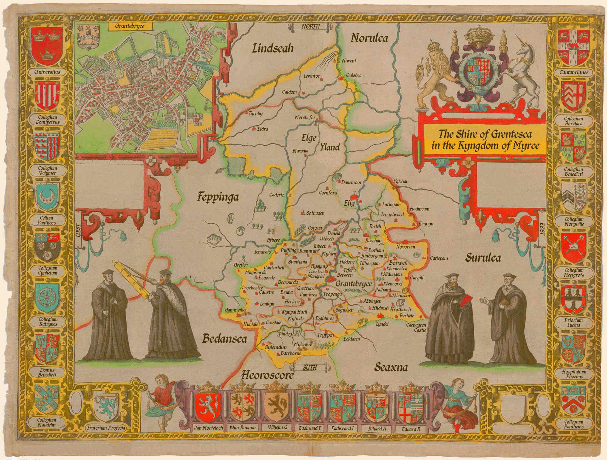
Grentesca
The shire of Grentesca is located in the easternmost portion of the kingdom of Myrce. The shire seat is the city of Grantebryce.
It is bordered by the shires of Lindseah on the northwest, Feppinga on the west, Bedansca on the southwest, and Heoroscore on the south. On the east, are the Denalagh filker Norulca to the north, Surulca in the middle, and Seaxna to the south.
Geography
The northern half of the shire consists of Elge Yland and the adjacent marshes of the Sanfhéith, while the southern half consists of Grantebryce and the surrounding lands.
A set of man-made waterways known as lodes connect the villages to the north-east of Grantebryce. These include Botts Lode, Swabble Lode, Rech Lode, and Burr Lode.
Other notable features include Brunnr Broc, the forest Buffewōd, Charre Dich, the Creant and Græwos rivers, Cwey Broc, Deofol Dich, and Goëmagoc Hylls.
History
Grentesca was formed as a shire of the Kingdom of Ænglar when Vilhelm Gervald was named first Earle of Grentesca in A.I. 1440 by Aldƿulf Ennius. He was succeeded by Eadmund in A.I. 1473, Eadweard Lisbet in A.I. 1526, Rikard Anell in A.I. 1555, and Eduard Reicart in A.I. 1585.
Grantebryce was occupied by the Tenneman in A.I. 1628, and the shire remained subject to the Denalagh until A.I. 1658 when it was liberated by Æthelflæs Ældrǣd and subsequently annexed into Myrce.
Boroughs
- Æbingen comprises two villages on either side of the Graund, seven miles south east of Grantebryce
- Bærborne is just north of the ancient track known as Escwel Stræte, 1½ miles north of the Iccenhyld Weg, and ¾ miles west of Ernyng Stræte.
- Berærnlies on the Ernyng Stræte ten miles west of Grantebryce and six miles south of Hentana.
- Becwurda is two miles east of Grantebryce on Niwmarch Rode.
- Berkele is on the Graund, twelve miles south-east of Grentesca and seven miles west of Hauerla (Ænglar).
- Borwen is six miles south of Novorum on Iccenhyld Weg
- Botham sits just north of Niwmarch Rode, about six miles east of Grantebryce, halfway to Novorum
- Bruna, on Brunnr Broc, is 8 miles west of Grantebryce.
- Caderiz is situated on a raised island in the Sanfhéith between Hentana, Mershefor and Elig
- Cæslaie lies south-east of the Buffewōd and 12 miles southwest of Grantebryce.
- Cæstra is situated on the north bank of the Granta, 1½ mile north-west of Grantebryce
- Canturkell stands about 9 miles west of Grantebryce.
- Cargill is situated about 7 miles south of Novorum and the same distance north-east of Lyndel.
- Catlepam, which is much scattered, stands about 6 miles south-east of Novorum.
- Caustre lies 9 miles west of Grantebryce and a short distance south-west of Ernyng Stræte.
- Coenford sits on a small island 3½ miles west of Elig as the crow flies.
- Cotoun is situated near the Charre Dich about 6½ miles north of Grantebryce
- Crochestre stands about 13 miles west of Grantebryce.
- Cumbres is about 5½ miles west-southwest of Cambridge.
- Cynewhyrđ sits on Ernyng Stræte about 1¼ mile southeast of Bærborne.
- Deneia
- Dunemoor is about 3 miles north of Elig at the north-west edge Elgy Ysland.
- Ecklarm is situated about 7 miles west from Lyndel and 11 miles south of Grantebryce.
- Ecgnynsits 9 miles northwest of Grantebryce and 7 miles southeast of Hentana
- Eldra is 13 miles southwest of Ouisbec and 9 miles west of Mershefor
- Elig sits atop Elge Yland 16 miles north-northeast of Grantebryce.
- Esuorde lies 9 miles northwest of Grantebryce. With 44 households.
- Fendrais
- Fiddone
- Foghlmor
- Forleh
- Gammenlei
- Grantebryce
- Greflea
- Grettune
- Gylemdun
- Hadincam
- Herlene
- Hildresh
- Hrothæch
- Hunlaie
- Hysymp
- Inbech
- Kinborgam
- Lengolwaed
- Levintor
- Lilborgam
- Lonkyn
- Lutingam
- Lyndel
- Magwurda
- Mangelei
- Mawnia
- Mershefor
- Mylenbre
- Mylden
- Mylrede
- Niwent
- Novorum
- Ofberc
- Ouisbec
- Palhaml
- Ræchan
- Rammurt
- Sagussen
- Sothaden
- Stantunia
- Teferu
- Tyrnby
- Tropenga
- Tryppen
- Utbech
- Vicusam
- Vindey
- Vuifling
- Wencovel
- Wildungan
- Wunlestra
- Wynpal Hæll
- Yglehan
Landmarks
- Cænagren Castle